Patagonia is a vast geographic region at the southern end of South America, shared by Argentina and Chile. It stretches across much of southern Argentina and Chile, from the Patagonian steppe and Andes Mountains to the Atlantic and Pacific coasts.
If you are wondering where Patagonia is located, it is not a country or city. It is a large geographic and cultural region that extends south toward the Strait of Magellan and Tierra del Fuego. The Andes form much of its western mountain landscape, while eastern Patagonia is known for open plains, steppe, and Atlantic coastline.
Patagonia is famous for its glaciers, rugged mountains, national parks, wildlife, lakes, fjords, and remote landscapes. Popular places include Torres del Paine, Perito Moreno Glacier, Mount Fitz Roy, Ushuaia, and Tierra del Fuego.
Featured Snippet Answer
Patagonia is a large geographic region in southern South America, shared by Argentina and Chile. It covers much of southern Argentina and Chile, extending from around the Colorado River region south toward the Strait of Magellan and Tierra del Fuego. Patagonia is not a country or city; it is known for its Andes Mountains, glaciers, national parks, wildlife, and dramatic landscapes.
Where Is Patagonia Located?
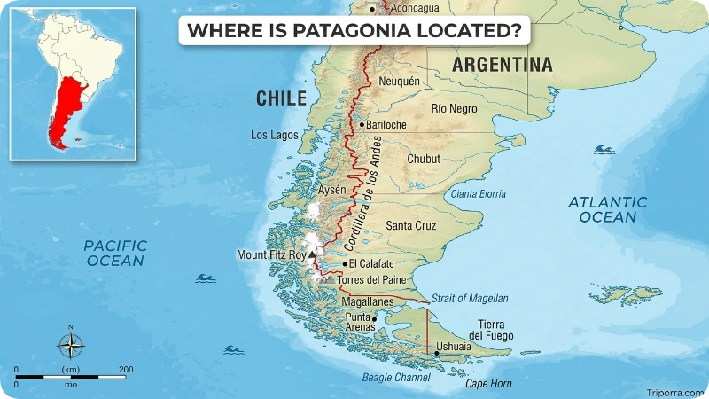
Patagonia is located in southern South America, where it covers parts of Argentina and Chile. Argentina occupies most of the eastern side, while Chile covers much of the western side along the Andes and Pacific coast.
The region generally begins around the Colorado River area in Argentina and extends south toward the Strait of Magellan and Tierra del Fuego. Because Patagonia is a geographic region rather than a political territory, its exact boundaries vary depending on the definition used.
In simple terms, Patagonia is:
- Continent: South America
- Countries: Argentina and Chile
- Location: Southern South America
- West: Chile, the Andes, and the Pacific side
- East: Argentina and the Atlantic coast
- South: Strait of Magellan and Tierra del Fuego
Patagonia is not a country, state, or city. It is a large geographic and cultural region containing cities, towns, national parks, mountains, glaciers, forests, grasslands, and coastal areas.
Continent
- South America
Countries
- Argentina
- Chile
Major Administrative Areas
Argentina:
- Neuquén
- Río Negro
- Chubut
- Santa Cruz
- Tierra del Fuego Province
Chile:
- Los Lagos (southern portions)
- Aysén Region
- Magallanes Region
Where Is Patagonia on a Map?
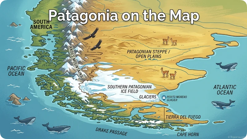
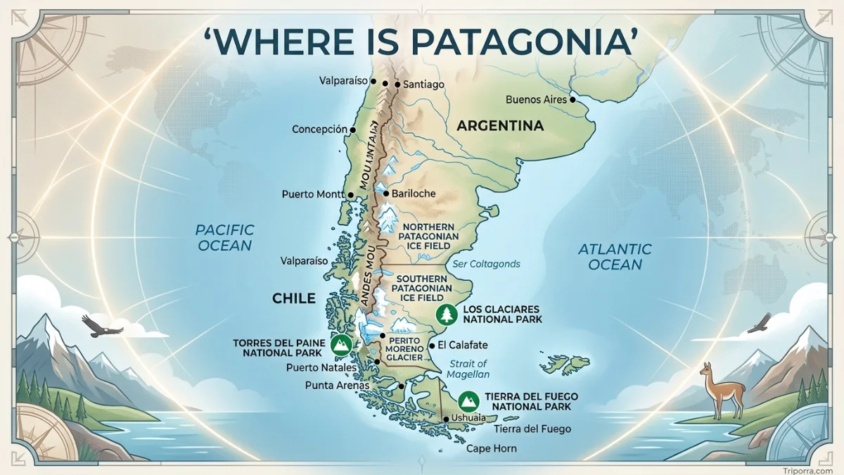
On a map of South America, Patagonia appears at the southern end of the continent. It covers a large area of southern Argentina and Chile, rather than appearing as one small point.
The Andes Mountains run along the western side of Patagonia and form a major natural divide between Argentina and Chile. Eastern Patagonia extends across Argentina toward the Atlantic Ocean, while Chilean Patagonia reaches toward the Pacific Ocean through mountains, islands, fjords, and channels.
To find Patagonia on a world map, first locate South America. Then look toward the southern end of the continent. Patagonia occupies much of the area across southern Argentina and Chile, extending south toward the Strait of Magellan and Tierra del Fuego.
Because Patagonia is so large, a map of Patagonia should be viewed as a broad region rather than a single location.
Patagonia Map Location at a Glance
| Direction | What You Find |
|---|---|
| North | Northern Patagonia and the Colorado River area |
| West | Chile, Andes Mountains, and Pacific coast |
| East | Argentina and Atlantic coast |
| South | Strait of Magellan and Tierra del Fuego |
| Continent | South America |
| Countries | Argentina and Chile |
Quick Facts About Patagonia
| Fact | Details |
|---|---|
| What is Patagonia? | Geographic and cultural region |
| Location | Southern South America |
| Continent | South America |
| Countries | Argentina and Chile |
| Region Type | Geographic region, not a country |
| Approximate Area | About 1 million sq km (386,000 sq mi) |
| Approximate Latitude | About 39°S–56°S |
| Major Cities | Neuquén, Bariloche, Comodoro Rivadavia, Ushuaia, Punta Arenas, Puerto Natales |
| Mountain System | Southern Andes |
| Major Landscapes | Mountains, glaciers, steppe, forests, lakes, fjords, and coastlines |
| Famous Attractions | Perito Moreno Glacier, Torres del Paine, Mount Fitz Roy, Los Glaciares National Park |
| Main Languages | Spanish, with English common in many tourist areas |
| Currencies | Argentine Peso (ARS) and Chilean Peso (CLP) |
| Known For | Glaciers, mountains, wildlife, hiking, national parks, and wilderness |
| Best Travel Season | Generally October to April for many outdoor activities |
Key Facts: Patagonia is a vast geographic region in southern South America shared by Argentina and Chile. It is famous for its spectacular glaciers, rugged mountains, unique wildlife, and world-class hiking destinations.
How Many People Live in Patagonia?
Patagonia does not have one official population figure because it is a geographic region rather than a separate political unit. Its population is spread across parts of Argentina and Chile.
Large cities such as Neuquén, Bariloche, Comodoro Rivadavia, Punta Arenas, and Puerto Natales are important population centers, while large parts of Patagonia remain sparsely populated.
The population also varies depending on how the boundaries of Patagonia are defined. For that reason, a population figure should always state which geographic definition it uses.
Is Patagonia Safe?
Patagonia is generally a safe destination for travelers, but visitors should prepare for the region’s remote geography and unpredictable weather.
Strong winds, sudden weather changes, difficult terrain, long driving distances, and limited services in remote areas can create greater risks than travelers may expect.
When hiking or traveling through remote areas, check weather conditions, follow park rules, carry suitable clothing and supplies, and let someone know your plans.
In cities and tourist areas, normal travel precautions such as protecting valuables and being aware of your surroundings are still recommended.
Is Patagonia Expensive to Visit?
Patagonia can be relatively expensive to visit, especially during the December-to-February peak season and in remote tourist destinations.
The biggest expenses can include accommodation, transportation, national park fees, guided activities, and long-distance travel between destinations. Remote areas may cost more because supplies and services have to travel long distances.
Travelers can reduce costs by visiting during the shoulder seasons, choosing simpler accommodation, using buses where practical, and planning transportation in advance.
The total cost depends heavily on which side of Patagonia you visit, how long you stay, and the type of activities you choose.
Is It Expensive to Live in Patagonia?
The cost of living in Patagonia varies considerably between cities, towns, and remote communities.
Some remote areas and popular tourist destinations can have higher prices for housing, food, transportation, and everyday goods because of their distance from major supply centers.
However, Patagonia is not one economic area. Living costs in a larger city such as Neuquén can differ significantly from those in a small rural community or tourist town.
Therefore, whether Patagonia is expensive to live in depends on the specific location and lifestyle.
Do They Speak English in Patagonia?
Spanish is the main language spoken in Patagonia. English is commonly used in hotels, tour companies, restaurants, and other tourism businesses in popular destinations.
However, English is less common in small towns and rural areas. Travelers who plan to explore remote parts of Patagonia should not rely entirely on English.
Knowing a few basic Spanish phrases can make communication easier, especially outside major tourist centers.
Which Countries Does Patagonia Belong To?
Patagonia is shared by Argentina and Chile. It does not belong entirely to either country.
Argentine Patagonia
Argentine Patagonia covers most of the eastern and central part of the region. It includes:
- Neuquén
- Río Negro
- Chubut
- Santa Cruz
- Tierra del Fuego Province
Popular destinations include Bariloche, El Calafate, El Chaltén, Puerto Madryn, and Ushuaia.
Chilean Patagonia
Chilean Patagonia lies mainly west of the Andes and includes extensive mountains, forests, glaciers, fjords, islands, and channels.
Important destinations include:
- Aysén Region
- Magallanes Region
- Puerto Natales
- Punta Arenas
- Torres del Paine National Park
So, if you search “what country is Patagonia in?”, the answer is Argentina and Chile.
What Is Patagonia?
Patagonia is a large geographic and cultural region in southern South America. It covers parts of Argentina and Chile and contains some of the most varied landscapes in the southern part of the continent.
The region includes the Andes Mountains, Patagonian steppe, glaciers, forests, lakes, rivers, fjords, and coastal areas. Its geography changes significantly from west to east and from north to south.
It is not an independent country, state, or city. Instead, it is a broad region made up of many administrative areas, cities, towns, national parks, and rural communities.
The name Patagonia is most strongly associated with wilderness, dramatic mountain scenery, glaciers, wildlife, and outdoor activities.
Is Patagonia a Country, City, or Place?
Patagonia is not a country and not a city. It is a large geographic and cultural region in southern South America.
It is a place in the geographic sense, but it does not have its own government, capital, or national borders. Argentina and Chile each administer different parts of the region.
This means:
- Patagonia is not a country.
- Patagonia is not a city.
- Patagonia is a geographic region.
- Patagonia is located in Argentina and Chile.
The region contains many cities and towns, including Bariloche, Neuquén, Ushuaia, Punta Arenas, and Puerto Natales.
Is Patagonia Part of the Andes?
The Andes Mountains are a major geographic feature of Patagonia, but Patagonia itself is not a mountain range.
The southern Andes run along the western side of Patagonia and help separate Argentina from Chile. They contain many of the region’s famous peaks, glaciers, valleys, and hiking areas.
However, it is much larger than the Andes. Eastern Patagonia includes broad areas of dry steppe and plains, while other parts contain forests, lakes, glaciers, and coastlines.
So, the simple answer is: Patagonia is a region, while the Andes are a mountain range that runs through its western side.
What Are the Patagonia Mountains?
The mountains of Patagonia are mainly part of the southern Andes. They form some of the most dramatic scenery in Argentina and Chile.
Well-known Patagonian mountain landmarks include:
- Mount Fitz Roy near El Chaltén
- Cerro Torre in Argentine Patagonia
- Torres del Paine in Chilean Patagonia
- The mountain ranges surrounding the Patagonian Andes
It is not itself a single mountain range. Instead, its mountain landscapes are part of a much larger geographic region that also includes plains, steppe, forests, glaciers, lakes, and coastlines.
What Are the Major Cities in Patagonia?
It does not have one capital or one main city because it is a geographic region shared by Argentina and Chile.
Important cities and urban centers include:
- Neuquén — one of the largest urban centers in Argentine Patagonia
- Bariloche — a major tourism and mountain destination
- Comodoro Rivadavia — an important city on Argentina’s Atlantic coast
- Puerto Madryn — known for marine wildlife and access to Peninsula Valdés
- Ushuaia — a major city in Tierra del Fuego
- Punta Arenas — an important city in Chilean Patagonia
- Puerto Natales — a gateway to Torres del Paine
Because Patagonia covers such a large area, these cities serve as gateways to different parts of the region.
How to Reach Patagonia
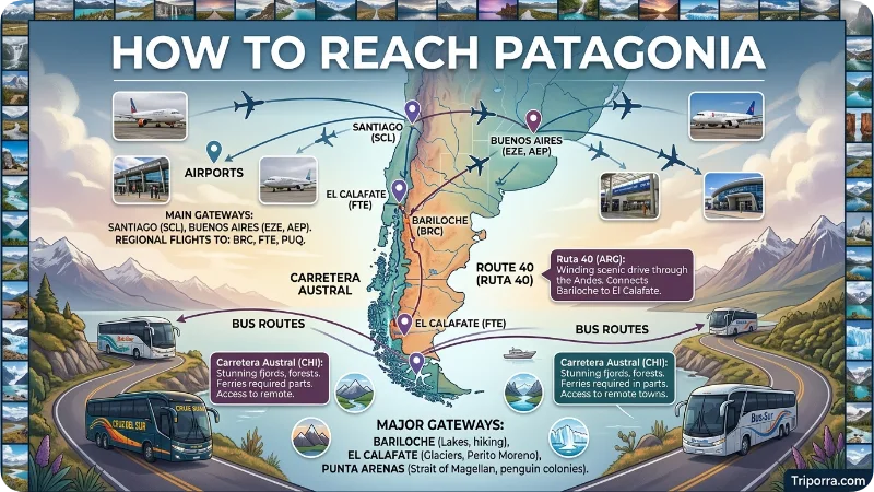
Because Patagonia covers a huge area, travel routes depend on which destination you plan to visit.
Where Is Patagonia Airport?
There is no single airport serving all of Patagonia because the region is extremely large. Instead, travelers fly to airports near their specific destination.
Important airports include Bariloche Airport, El Calafate Airport, Ushuaia Airport, Neuquén Airport, Punta Arenas Airport, Balmaceda Airport, and Puerto Natales Airport.
International travelers often connect through Buenos Aires in Argentina or Santiago in Chile before flying farther south.
The best airport depends on where you want to go in it. For example, El Calafate is convenient for travelers visiting Perito Moreno Glacier, while Punta Arenas and Puerto Natales are useful gateways to Chilean Patagonia.
By Air
Major airports include:
Argentina
- Bariloche Airport
- El Calafate Airport
- Ushuaia Airport
- Neuquén Airport
Chile
- Punta Arenas Airport
- Balmaceda Airport
- Puerto Natales Airport
Most international travelers connect through:
- Buenos Aires
- Santiago, Chile
By Road
Long-distance highways connect major Patagonian cities.
Popular routes include:
- Argentina’s Route 40
- Chile’s Carretera Austral
These roads pass through some of the region’s most spectacular scenery.
By Bus
Intercity buses are common and connect towns throughout it .
By Cruise
Some travelers arrive through cruises that visit:
- Ushuaia
- Cape Horn
- Chilean fjords
- Antarctic departure points
Why Is Patagonia Famous?
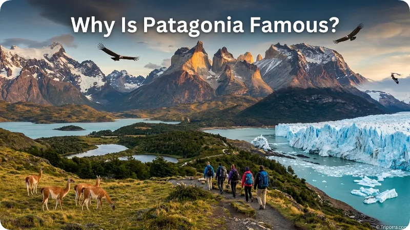
It is famous for its dramatic natural landscapes and remote wilderness. The region combines glaciers, mountains, forests, lakes, grasslands, fjords, coastlines, and diverse wildlife across a huge area of southern Argentina and Chile.
Visitors come to it for hiking, trekking, wildlife watching, photography, mountaineering, kayaking, and sightseeing. Famous places such as Torres del Paine, Perito Moreno Glacier, Mount Fitz Roy, and Los Glaciares National Park have made Patagonia one of the world’s best-known wilderness destinations.
Glaciers
The region contains some of the world’s largest ice fields outside Antarctica and Greenland.
Famous examples include:
- Perito Moreno Glacier
- Grey Glacier
- Upsala Glacier
Mountains
Many travelers come specifically for mountain scenery.
Highlights include:
- Mount Fitz Roy
- Cerro Torre
- Torres del Paine
Wildlife
It supports diverse wildlife such as:
- Guanacos
- Pumas
- Andean condors
- Penguins
- Southern right whales
- Sea lions
National Parks
Protected areas attract millions of visitors.
Major parks include:
- Torres del Paine National Park
- Los Glaciares National Park
- Nahuel Huapi National Park
Adventure Tourism
Popular activities include:
- Hiking
- Trekking
- Kayaking
- Rock climbing
- Wildlife watching
- Horseback riding
- Photography
History of Patagonia
Human history in Patagonia stretches back thousands of years.
Indigenous Peoples
Before European arrival, the region was home to several Indigenous groups, including:
- Mapuche
- Tehuelche
- Selk’nam
- Yaghan
These communities adapted to Patagonia’s challenging environments and developed distinct cultures.
European Exploration
European explorers reached Patagonia during the Age of Exploration.
Portuguese navigator Ferdinand Magellan traveled through the region in the early 1500s while sailing for Spain.
Settlement and Development
During the nineteenth century, Argentina and Chile expanded settlement and established greater control over Patagonian territories.
Sheep farming became a major economic activity, especially in open grassland areas.
Modern Patagonia
Today, tourism, conservation, energy production, agriculture, and fishing play important roles in the regional economy.
Why Is It Called Patagonia?
The name it dates back to the early European exploration of southern South America. It became associated with the region during the expedition of Ferdinand Magellan in the early 1500s.
The exact origin and meaning of the name have been debated, but European explorers used the name Patagonia for the southern part of the continent and its Indigenous inhabitants.
Today, Patagonia refers to the broad geographic and cultural region shared by Argentina and Chile.
Climate and Weather
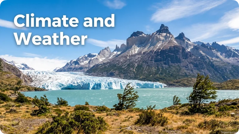
It has a highly varied climate because it covers such a large area and includes mountains, plains, forests, glaciers, and coastal environments. Conditions can change significantly between western Chilean Patagonia and eastern Argentine Patagonia.
Western areas near the Pacific and Andes are generally wetter and cooler, while eastern Patagonia is generally drier and windier.
Patagonia can experience strong winds and rapid weather changes throughout the year, especially in exposed mountain and steppe areas.
Patagonia experiences significant climatic variation due to its size and geography.
Western Patagonia
The Pacific side is generally:
- Cooler
- Wetter
- More forested
Some areas receive heavy rainfall throughout the year.
Eastern Patagonia
The Atlantic side is generally:
- Drier
- Windier
- Less densely forested
Large grasslands dominate much of the landscape.
Seasonal Overview
Summer (December–February)
- Mild to warm temperatures
- Peak travel season
- Long daylight hours
Autumn (March–May)
- Colorful landscapes
- Fewer visitors
Winter (June–August)
- Snow in mountain regions
- Ski opportunities
- Shorter days
Spring (September–November)
- Wildflowers
- Increasing wildlife activity
Strong winds can occur year-round, especially during spring and summer.
Is Patagonia Cold?
It can be cold, but temperatures vary greatly across the region.
Mountain areas and southern locations can remain cold even during summer, while some lower and northern areas can have relatively mild summer conditions. Winter brings snow to many mountain areas, and strong winds can make conditions feel much colder.
Summer, from December through February, is generally the most popular period for hiking and sightseeing because of longer daylight hours. However, weather can change quickly even during summer.
If you visit Patagonia, prepare for changing conditions rather than expecting one temperature across the entire region.
Best Places to See in Patagonia
Patagonia covers a huge area, so the best places to visit depend on whether you want mountains, glaciers, wildlife, hiking, or coastal scenery. Some of the region’s best-known destinations include:
It contains countless attractions.
Torres del Paine National Park
One of South America’s most famous parks, known for granite towers, lakes, and hiking trails.
Perito Moreno Glacier
A massive glacier famous for dramatic ice calving events.
Mount Fitz Roy
An iconic peak that attracts hikers and photographers.
Ushuaia
Often called the world’s southernmost city.
Peninsula Valdés
A UNESCO World Heritage Site known for marine wildlife.
Nahuel Huapi National Park
Popular for lakes, forests, and mountain scenery.
Carretera Austral
A scenic highway crossing remote Chilean Patagonia.
Where Is Patagonia National Park?
Patagonia National Park is in Chile’s Aysén Region, in northern Chilean Patagonia. It protects a large landscape of grasslands, mountains, forests, rivers, and wildlife habitats.
Patagonia National Park is one specific protected area within the much larger geographic region called Patagonia. It should not be confused with Torres del Paine National Park in Chile or Los Glaciares National Park in Argentina.
The park is a destination for travelers interested in hiking, wildlife, mountain scenery, and remote landscapes in Chilean Patagonia.
Best Time to Visit
The ideal time depends on your goals.
Peak Season
December to February
Best for:
- Hiking
- Sightseeing
- Wildlife viewing
Shoulder Season
October–November and March–April
Benefits:
- Fewer crowds
- Pleasant weather
- Lower accommodation demand
Off-Season
May to September
Best for:
- Winter sports
- Snow landscapes
- Quiet travel experiences
Travelers planning long hikes usually prefer the summer months.
What Else Do People Want to Know?
Is Patagonia Safe?
It is generally considered one of the safer travel regions in South America. Standard travel precautions are recommended.
Is Patagonia Expensive?
Costs vary significantly. Remote locations and peak-season travel can increase expenses, especially for accommodation and transportation.
Do People Live in Patagonia?
Yes. Hundreds of thousands of people live throughout Patagonia in cities, towns, and rural communities.
Is English Spoken?
Spanish is the primary language, but English is commonly used in major tourist destinations.
How Large Is Patagonia?
Depending on the definition used, Patagonia covers roughly one million square kilometers, making it one of the world’s largest geographic regions.
Places Related to Patagonia
People searching for it often look for these connected destinations:
- Torres del Paine National Park
- El Calafate
- El Chaltén
- Ushuaia
- Bariloche
- Tierra del Fuego
- Punta Arenas
- Puerto Natales
- Peninsula Valdés
- Cape Horn
- Antarctica
These locations are frequently included in Patagonia travel itineraries.
Pictures of Patagonia
Pictures of it show the remarkable variety of landscapes found across southern Argentina and Chile. The region includes glaciers, snow-covered mountains, turquoise lakes, forests, open steppe, fjords, and coastlines.
Some of the most photographed places include Torres del Paine, Perito Moreno Glacier, Mount Fitz Roy, Cerro Torre, and Tierra del Fuego.
A photo gallery showing different parts of Patagonia can help readers understand that the region is much more than glaciers and mountains.
FAQs
Where is Patagonia located?
It is located in southern South America and covers parts of Argentina and Chile. It extends south toward the Strait of Magellan and Tierra del Fuego.
Which country does Patagonia belong to?
It is shared by Argentina and Chile. Argentina contains most of the eastern portion, while Chile covers much of the western portion.
Is Patagonia a country?
No. Patagonia is a geographic and cultural region, not an independent country.
Is Patagonia a city?
No. Patagonia is a large region containing cities such as Bariloche, Neuquén, Ushuaia, Punta Arenas, and Puerto Natales.
Where is Patagonia on a map?
Patagonia is at the southern end of South America. It covers a large area of southern Argentina and Chile, with the Andes forming a major feature along its western side.
Is Patagonia part of the Andes?
The Andes are a major mountain system within Patagonia, particularly along its western side. Patagonia itself is a much larger geographic region that also includes plains, steppe, forests, glaciers, and coastlines.
Why is Patagonia called Patagonia?
The name Patagonia dates to the early European exploration of southern South America and became associated with the region during Ferdinand Magellan’s expedition in the early 1500s.
Is Patagonia cold?
It can be cold, especially in winter, at higher elevations, and in southern areas. Summer can be mild or warm in some locations, but strong winds and changing weather are common.
Is Patagonia safe?
It is generally considered safe for travelers, but visitors should prepare for strong winds, changing weather, difficult terrain, and long distances in remote areas.
Is Patagonia expensive to visit?
Patagonia can be expensive, particularly during the summer peak season. Accommodation, transportation, park fees, and guided activities can increase the overall cost.
Is it expensive to live in Patagonia?
Living costs vary widely. Remote locations and tourist towns can be expensive, while larger cities have different housing and everyday costs.
Do they speak English in Patagonia?
Spanish is the main language. English is common in many tourism businesses but is less widely spoken in rural areas and smaller towns.
Where is Patagonia National Park?
Patagonia National Park is in Chile’s Aysén Region in northern Chilean Patagonia. It is one specific protected area within the broader Patagonia region.
Where is Patagonia Airport?
There is no single airport for the entire Patagonia region. Travelers use different airports near destinations such as Bariloche, El Calafate, Ushuaia, Punta Arenas, and Puerto Natales.
How large is Patagonia?
It covers roughly 1 million square kilometers under a commonly used definition, although the exact area varies depending on how its boundaries are defined.
How many people live in Patagonia?
There is no single official population figure because Patagonia is a geographic region rather than a political unit. Its population is spread across cities, towns, and rural communities in Argentina and Chile.
What is Patagonia known for?
It is known for its glaciers, mountains, national parks, wildlife, hiking, outdoor adventures, lakes, fjords, and remote wilderness.
What is the best time to visit Patagonia?
December through February is the most popular period for many outdoor activities because of longer daylight hours and generally milder conditions. October, November, March, and April can offer fewer crowds.
Conclusion
Patagonia is a vast region in southern South America shared by Argentina and Chile. Stretching from the Andes Mountains to the Atlantic and Pacific coasts, it contains glaciers, national parks, wildlife habitats, rugged peaks, and remote landscapes that attract travelers from around the world. Whether you are interested in hiking beneath the towers of Torres del Paine, viewing the Perito Moreno Glacier, exploring Tierra del Fuego, or simply understanding where it is located, the region remains one of Earth’s most remarkable natural destinations.

Elena Rostova bridges the gap between premium hospitality and authentic local experiences. Armed with a background in luxury hospitality management and a passion for fine architecture, she spent years evaluating elite resorts before transitioning into travel journalism. Elena heads the luxury and boutique travel vertical on Triporra.com. Her meticulous guides strip away the guesswork from high-end travel, showcasing unique five-star escapes, fine regional dining, and bespoke private tours that elevate a standard vacation into an unforgettable journey.