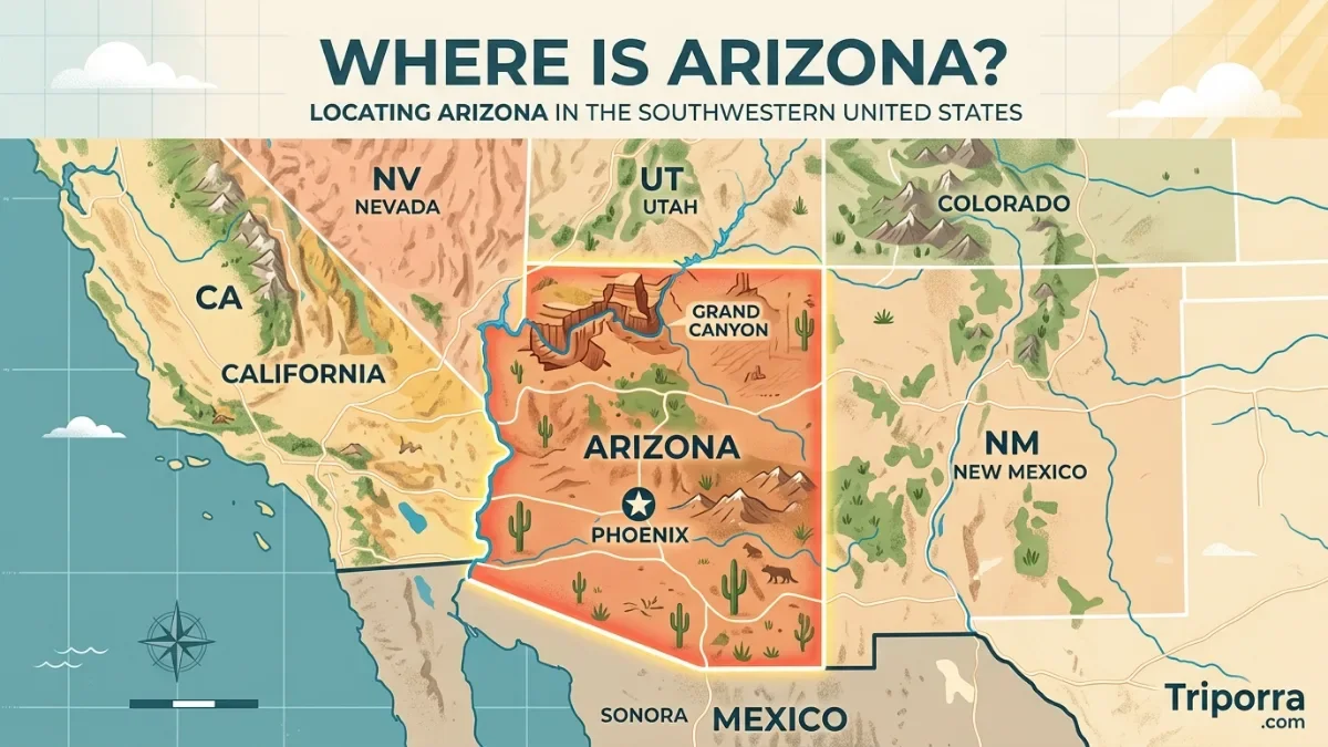
It is a state in the southwestern United States. It is located between California and New Mexico, with borders touching Nevada, Utah, Colorado, and Mexico. Many people search where is Arizona because of its famous landmarks, including the Grand Canyon, desert landscapes, Native American heritage sites, and growing cities like Phoenix and Tucson.
The state covers a large area of the American Southwest and is known for its warm climate, mountain ranges, deserts, forests, and outdoor destinations. It is the sixth-largest U.S. state by land area and one of the most visited states in the country. Its capital city is Phoenix, which is also the largest city in it .
It is a state in the southwestern United States, bordered by California, Nevada, Utah, Colorado, New Mexico, and Mexico. It covers approximately 113,990 square miles (295,234 square kilometers) and is famous for the Grand Canyon, Sonoran Desert, red rock landscapes, Native American cultures, and cities such as Phoenix and Tucson.
Quick Facts About Arizona
| Fact | Information |
|---|---|
| Official Name | State of Arizona |
| Country | United States |
| Region | Southwestern United States |
| Capital City | Phoenix |
| Largest City | Phoenix |
| Statehood | February 14, 1912 (48th U.S. state) |
| Area | Approximately 113,990 sq mi (295,234 sq km) |
| Population | Approximately 7.4 million (2025 estimate) |
| Approximate Coordinates | 34° N, 112° W |
| Highest Point | Humphreys Peak – 12,633 ft (3,851 m) |
| Lowest Point | Colorado River near Yuma – about 70 ft (21 m) above sea level |
| Time Zone | Mountain Standard Time (MST, UTC−7); most of Arizona does not observe daylight saving time |
| Major Cities | Phoenix, Tucson, Mesa, Chandler, Scottsdale, Flagstaff |
| State Nickname | The Grand Canyon State |
| Known For | Grand Canyon, deserts, red rocks, national parks, Native American history |
| Official Language | No official state language; English is the most widely spoken |
| Currency | United States Dollar (USD) |
Where Is Arizona Located on the Map?
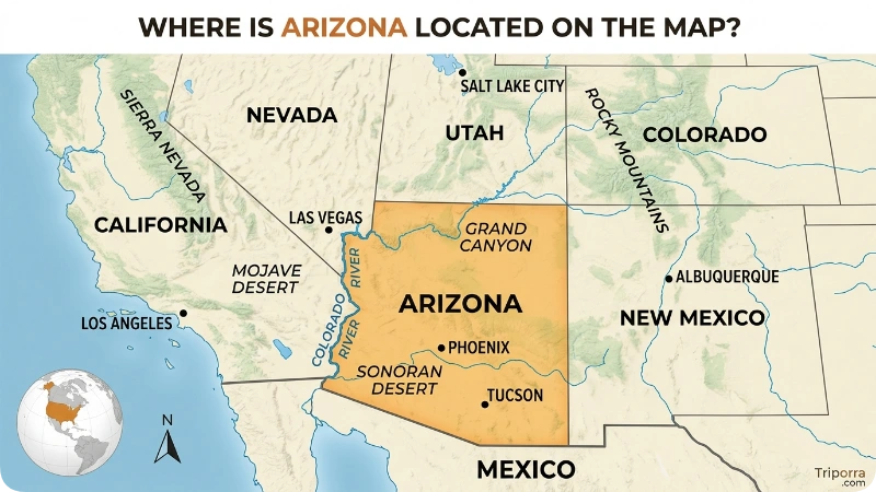
It is located in the southwestern part of the United States. It sits in the western half of the country, below Utah and west of New Mexico. The state is part of the larger Southwest region, which also includes states such as Nevada, California, New Mexico, and Utah.
On a map of the United States, Arizona appears as a large rectangular-shaped state near the western border. Its southern edge reaches Mexico, while its western side connects with California and Nevada.
Arizona’s approximate geographic position is between 31° and 37° north latitude and 109° and 115° west longitude. The state includes deserts in the south, forests and mountains in the north, and high plateaus in the central region.
The state’s location gives it a wide variety of landscapes. A person can travel from hot desert areas near Phoenix to cool mountain forests around Flagstaff within a few hours.
What State and Country Is Arizona In?
Arizona is a state within the United States of America. Arizona is not a country, city, or territory. It became the 48th state of the United States on February 14, 1912.
It is part of the U.S. Southwest region. It shares borders with six areas:
- California to the west
- Nevada to the northwest
- Utah to the north
- Colorado at the northeast corner
- New Mexico to the east
- Mexico to the south
Arizona’s international border with Mexico is about 389 miles (626 kilometers) long. The border connects Arizona with the Mexican states of Sonora and a small section near Baja California.
What States Border Arizona?
It has five neighboring U.S. states and one international neighbor. Its borders create important connections between western and southwestern parts of the country.
Arizona’s neighboring states:
California
California lies west of it . The two states are connected by major highways and the Colorado River forms part of their boundary.
Nevada
Nevada is northwest of it . The famous city of Las Vegas is relatively close to Arizona’s western border.
Utah
Utah is north of it . The two states share access to the Colorado Plateau, an area known for dramatic landscapes and national parks.
Colorado
Colorado touches it at a small four-corner area called the Four Corners Monument, where Arizona, Colorado, New Mexico, and Utah meet.
New Mexico
New Mexico forms Arizona’s eastern border. The two states are connected through highways, trade routes, and cultural ties.
Mexico
It shares a southern international border with Mexico, mainly with the Mexican state of Sonora.
What Is Arizona Known For?
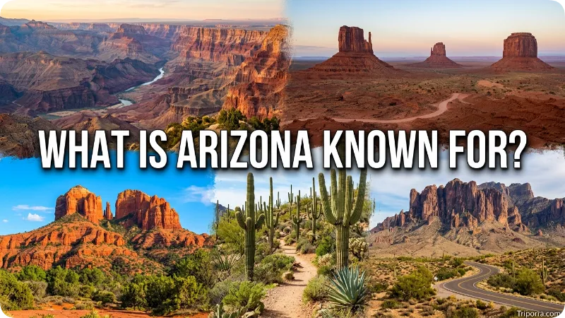
It is best known for its natural landscapes, especially the Grand Canyon, one of the most recognized geological features in the world. The state attracts visitors for its deserts, mountains, forests, and outdoor activities.
Some of Arizona’s most famous features include:
- Grand Canyon National Park – A massive canyon carved by the Colorado River
- Sonoran Desert – One of the most biologically diverse deserts in North America
- Monument Valley – A famous landscape of red sandstone formations
- Saguaro National Park – Home to giant saguaro cactus forests
- Petrified Forest National Park – Known for ancient fossilized trees
- Sedona red rocks – Famous for colorful sandstone formations
It is also known for its Native American communities. The state is home to several tribal nations, including the Navajo Nation, which is the largest Native American reservation in the United States by land area.
Where Is Phoenix, Arizona?
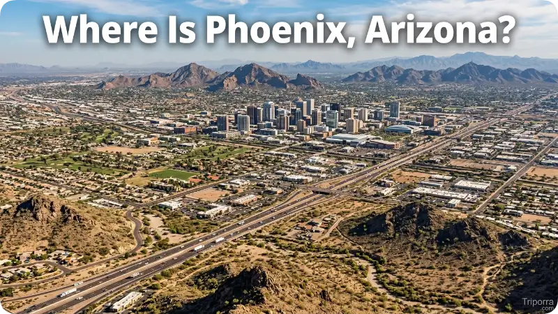
Phoenix is located in the central part of Arizona and is the state capital. It is also the largest city in it and one of the largest cities in the United States by population.
Phoenix sits in the Salt River Valley, also called the Valley of the Sun. The city is surrounded by desert mountains and is part of the Sonoran Desert.
Approximate distances from Phoenix:
DestinationDistance TypeApproximate DistanceTucson, ArizonaDriving distanceAbout 115 miles (185 km)Las Vegas, NevadaDriving distanceAbout 300 miles (483 km)Los Angeles, CaliforniaDriving distanceAbout 370 miles (595 km)Grand Canyon South RimDriving distanceAbout 230 miles (370 km)Albuquerque, New MexicoDriving distanceAbout 470 miles (756 km)
Driving times can change depending on traffic, road conditions, weather, and travel routes.
Phoenix is known for its business growth, desert climate, sports teams, museums, restaurants, and nearby outdoor areas.
What Cities Are Near Arizona?
Several major cities are located close to Arizona or within a short travel distance. The nearest city depends on which part of it you are visiting.
Major nearby cities include:
- Las Vegas, Nevada – Located northwest of Arizona and a popular travel connection
- San Diego, California – A major coastal city west of Arizona
- Los Angeles, California – A large city commonly connected by road and air travel
- Albuquerque, New Mexico – Located east of Arizona
- Salt Lake City, Utah – Located north of Arizona
Within it , major cities include:
Phoenix
The capital and largest urban area.
Tucson
A southern Arizona city known for desert landscapes, universities, and cultural attractions.
Flagstaff
A northern it mountain city with cooler weather and access to the Grand Canyon.
Mesa
A large city east of Phoenix with museums, parks, and outdoor recreation.
Scottsdale
Known for resorts, golf courses, art galleries, and desert scenery.
How Far Is Arizona From Major U.S. Cities?
| City | Approximate Distance From Phoenix | Distance Type |
|---|---|---|
| Los Angeles, California | About 370 miles (595 km) | Driving distance |
| Las Vegas, Nevada | About 300 miles (483 km) | Driving distance |
| Denver, Colorado | About 860 miles (1,384 km) | Driving distance |
| Dallas, Texas | About 1,060 miles (1,706 km) | Driving distance |
| Chicago, Illinois | About 1,750 miles (2,816 km) | Driving distance |
| New York City, New York | About 2,400 miles (3,862 km) | Flight distance varies |
How to Get to Arizona?
It is easy to reach by air, road, and rail. The state has several airports and major highways connecting it with other parts of the United States.
By Air
The largest airport is:
Phoenix Sky Harbor International Airport (PHX)
It serves Phoenix and the surrounding region with domestic and international flights.
Other important airports include:
- Tucson International Airport (TUS)
- Flagstaff Pulliam Airport (FLG)
- Yuma International Airport (YUM)
- Harry Reid International Airport in nearby Las Vegas, Nevada, for some western Arizona trips
By Road
Major highways connecting Arizona include:
- Interstate 10 (I-10) – Runs east-west through southern Arizona
- Interstate 17 (I-17) – Connects Phoenix and northern Arizona
- Interstate 40 (I-40) – Crosses northern Arizona
- U.S. Route 89 – Important route for northern attractions
By Train
Amtrak provides passenger rail service through Arizona, including routes connecting major western cities.
What Is the Climate Like in Arizona?
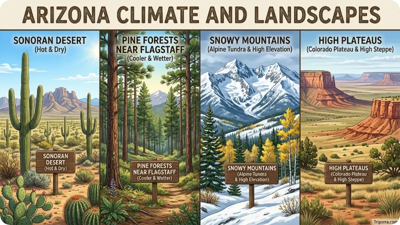
Arizona has a wide range of climates because of its elevation changes. The southern desert areas are much hotter than the northern mountain regions.
Southern Arizona
Cities like Phoenix and Tucson have a desert climate:
- Very hot summers
- Mild winters
- Low humidity
- Limited rainfall
Phoenix temperatures often exceed 100°F (38°C) during summer months.
Northern Arizona
Places like Flagstaff experience cooler conditions:
- Snowy winters
- Mild summers
- Mountain forests
- Four distinct seasons
The Grand Canyon’s temperature also changes greatly depending on elevation. The South Rim is much cooler than desert areas nearby.
Best Time to Visit Arizona
The best time to visit Arizona depends on what activities you want to do.
Spring (March to May)
Spring is one of the most comfortable seasons for outdoor activities. Temperatures are usually pleasant, and desert areas have blooming wildflowers.
Fall (September to November)
Fall brings cooler weather and is popular for hiking, sightseeing, and national park visits.
Winter (December to February)
Winter is ideal for exploring southern Arizona because temperatures are mild. Northern areas may have snow.
Summer (June to August)
Summer can be extremely hot in desert cities. However, higher-elevation areas such as Flagstaff provide cooler conditions.
A Brief History of Arizona
Arizona has a long history shaped by Indigenous cultures, Spanish exploration, mining, agriculture, and modern development. The region has been home to Native American peoples for thousands of years, including the Navajo, Hopi, Apache, Hualapai, and many other tribal nations.
Before becoming a U.S. state, Arizona was part of several political regions. Spain claimed the area during the colonial period, and later Mexico controlled the land after gaining independence from Spain in 1821. After the Mexican-American War, much of present-day Arizona became part of the United States through the Treaty of Guadalupe Hidalgo in 1848 and the Gadsden Purchase in 1853.
Arizona became a U.S. territory in 1863. During the late 1800s and early 1900s, mining played an important role in economic growth, especially copper mining. Arizona officially joined the United States as the 48th state on February 14, 1912.
Today, Arizona combines ancient Indigenous traditions, historic towns, modern cities, and major industries such as technology, tourism, healthcare, and manufacturing.
Population, Language, and Culture of Arizona
Arizona has a population of approximately 7.4 million people (2025 estimate). Most residents live in the Phoenix metropolitan area, which is one of the fastest-growing urban areas in the United States.
The state has a diverse population with influences from Native American, Mexican, European, and other cultural backgrounds.
Languages Spoken in Arizona
Arizona does not have an official state language. English is the most commonly spoken language, while Spanish is also widely used because of Arizona’s location near Mexico and its long history with Spanish-speaking communities.
Many Native American languages are also spoken within tribal communities.
Culture
Arizona’s culture reflects:
- Native American traditions and art
- Southwestern architecture
- Mexican and Hispanic influences
- Desert lifestyle
- Outdoor recreation
- Western history
The state hosts museums, cultural centers, festivals, and events that highlight its diverse communities.
Is Arizona a Desert State?
Yes, Arizona is widely considered a desert state, but it is not entirely desert. The state contains several different landscapes, including deserts, forests, mountains, and high plateaus.
The most famous desert region is the Sonoran Desert, which covers much of southern Arizona. It is known for the giant saguaro cactus, which grows naturally only in parts of the Sonoran Desert.
Arizona also contains:
- Colorado Plateau in the north
- Mountain ranges throughout the state
- Ponderosa pine forests near Flagstaff
- Alpine environments at higher elevations
This variety means Arizona can have extremely hot desert areas and snowy mountain regions at the same time.
⭐ Did You Know? Arizona has one of the largest elevation changes in the United States, from low desert areas near the Colorado River to mountain peaks above 12,000 feet (3,658 meters).
Famous Places to Visit in Arizona
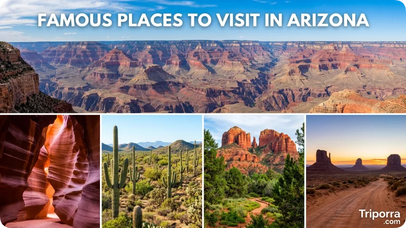
Arizona is one of the most visited states in the United States because of its natural attractions and outdoor destinations.
Grand Canyon National Park
The Grand Canyon is Arizona’s most famous landmark. The Colorado River carved the canyon over millions of years, creating cliffs, rock layers, and viewpoints that attract visitors from around the world.
Popular activities include:
- Scenic viewpoints
- Hiking
- River trips
- Photography
- Ranger programs
Monument Valley
Located near the Arizona-Utah border, Monument Valley is famous for its towering sandstone formations. It is part of the Navajo Nation and has been featured in many films and photographs.
Sedona
Sedona is known for its red sandstone landscapes, hiking trails, and outdoor recreation. The surrounding Coconino National Forest provides opportunities for hiking and sightseeing.
Antelope Canyon
Antelope Canyon near Page, Arizona, is famous for its narrow sandstone passages shaped by water erosion. Access is managed through guided tours.
Saguaro National Park
Located near Tucson, this national park protects large areas of the Sonoran Desert and its iconic saguaro cactus forests.
National Parks and Outdoor Activities in Arizona
It offers many outdoor activities because of its varied terrain.
Major outdoor destinations include:
PlaceKnown ForGrand Canyon National ParkCanyon views, hiking, geologySaguaro National ParkGiant cactus forestsPetrified Forest National ParkFossilized wood and desert landscapesOrgan Pipe Cactus National MonumentDesert ecosystemsGlen Canyon National Recreation AreaLake Powell and water activitiesChiricahua National MonumentRock formations and hiking
Popular activities include:
- Hiking
- Camping
- Rock climbing
- Wildlife viewing
- Photography
- River rafting
- Stargazing
Arizona’s dark skies also make it a popular location for astronomy, especially around rural areas away from city lights.
Is Arizona Safe to Visit?
It is generally a safe destination for travelers, but safety depends on the location, season, and activity. Like any state, some urban areas have higher crime rates than others.
Visitors should take basic precautions:
- Drink enough water during outdoor activities
- Avoid extreme midday heat during summer
- Carry supplies when hiking in remote areas
- Check weather conditions before traveling
- Follow park and trail safety rules
Desert environments can be challenging because temperatures, terrain, and wildlife may create risks.
Common natural hazards include:
- Extreme heat
- Flash floods
- Strong sun exposure
- Rattlesnakes and other desert wildlife
- Sudden weather changes in mountain areas
What Is the Best Time to Visit the Grand Canyon?
The best times to visit the Grand Canyon are usually spring (March to May) and fall (September to November) because temperatures are more comfortable.
Summer is the busiest season and can be very hot, especially in lower elevations. Winter offers fewer crowds, but snow and cold temperatures are common at the South Rim.
The Grand Canyon has different conditions depending on location:
- South Rim: Open year-round and easier to access
- North Rim: Higher elevation and seasonal access
- Inner Canyon: Much hotter than the rim areas
Visitors should check current conditions before hiking or traveling.
Common Misconceptions About Arizona
Many people have incorrect ideas about it because of its desert reputation.
“Arizona is completely flat and covered in sand”
This is false. Arizona has mountains, forests, lakes, canyons, and snowy areas. Northern Arizona looks very different from the desert areas around Phoenix.
“It is hot everywhere all year”
Arizona has extreme summer heat in desert regions, but mountain communities experience cold winters and snowfall.
“The Grand Canyon is close to Phoenix”
The Grand Canyon is in northern Arizona. From Phoenix, the drive to the South Rim is approximately 230 miles (370 km) and usually takes several hours depending on traffic and stops.
“Arizona has no water”
Arizona has rivers, lakes, reservoirs, and underground water systems. Water management is an important issue because much of the state has a dry climate.
Did You Mean a Different Place?
The search term “where is Arizona” usually refers to the U.S. state. However, the name it can sometimes appear in other contexts, including businesses, streets, schools, and organizations.
If you are searching for a specific place called Arizona outside the United States, you may need to add more details, such as:
- City name
- Country
- Organization name
- Address
The most recognized meaning of Arizona is the state in the southwestern United States.
FAQs
Where is Arizona located in the United States?
It is located in the southwestern United States. It borders California, Nevada, Utah, Colorado, New Mexico, and Mexico. The state is part of the American Southwest and is known for deserts, mountains, national parks, and cities such as Phoenix and Tucson.
Is Arizona a state or a city?
Arizona is a U.S. state, not a city. It became the 48th state of the United States on February 14, 1912. Phoenix is the capital and largest city of Arizona.
What country is Arizona in?
It is in the United States of America. It is one of the 50 U.S. states and is located in the southwestern region of the country.
What is Arizona famous for?
Arizona is famous for the Grand Canyon, Sonoran Desert, red rock landscapes, Native American heritage, national parks, and cities like Phoenix and Sedona. It is also known for outdoor activities such as hiking and sightseeing.
Is Arizona close to California?
Yes, it borders California to the west. The distance depends on the starting point, but Phoenix is approximately 370 miles (595 km) from Los Angeles by road.
What is the capital of Arizona?
The capital of it is Phoenix. Phoenix is also the largest city in the state and a major economic and cultural center.
Does Arizona get snow?
Yes, parts of Arizona receive snow, especially higher-elevation areas such as Flagstaff and the northern mountains. Desert cities like Phoenix rarely receive measurable snowfall.
What language is spoken in Arizona?
English is the most widely spoken language in it . Spanish is also commonly used, and many Native American languages continue to be spoken within tribal communities.
Is Arizona a good place to visit?
Yes, it is a popular travel destination because of its natural attractions, national parks, hiking opportunities, and cultural sites. The best time to visit depends on the region and activities planned.
How far is Arizona from Mexico?
Arizona shares a southern border with Mexico. The international boundary is approximately 389 miles (626 km) long and connects Arizona with the Mexican state of Sonora.
Conclusion
Arizona is located in the southwestern United States and is one of the most geographically diverse states in the country. It shares borders with California, Nevada, Utah, Colorado, New Mexico, and Mexico. The state is best known for the Grand Canyon, Sonoran Desert, red rock landscapes, Native American cultures, and cities such as Phoenix and Tucson.
From hot desert valleys to snowy mountain forests, Arizona offers a wide range of environments within one state. Its history, natural attractions, and outdoor activities make it an important destination for travelers and a growing home for millions of residents.
Whether you are looking for Arizona on a map, planning a visit, or simply learning about the state, the key answer is clear: It is a southwestern U.S. state between California and New Mexico, with a southern border connected to Mexico.

Elena Rostova bridges the gap between premium hospitality and authentic local experiences. Armed with a background in luxury hospitality management and a passion for fine architecture, she spent years evaluating elite resorts before transitioning into travel journalism. Elena heads the luxury and boutique travel vertical on Triporra.com. Her meticulous guides strip away the guesswork from high-end travel, showcasing unique five-star escapes, fine regional dining, and bespoke private tours that elevate a standard vacation into an unforgettable journey.