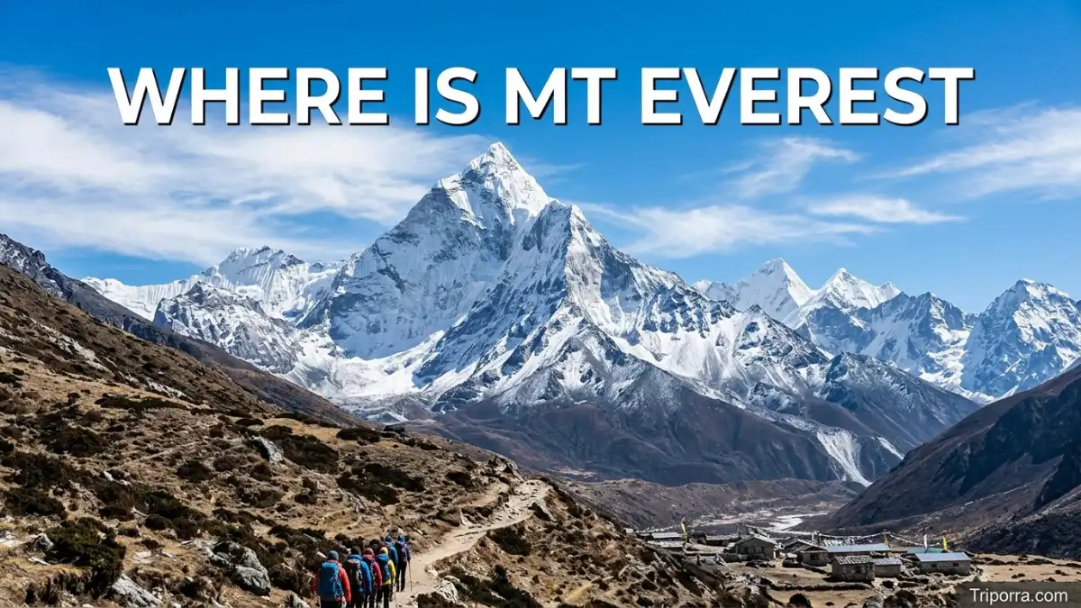
Where is Mt Everest? Mt Everest is on the border between Nepal and the Tibet Autonomous Region of China, in the Mahalangur Himal section of the Himalayas. It is the highest mountain on Earth above sea level and is famous for its great height, difficult climbing routes, unique culture, and dramatic Himalayan scenery.
The mountain’s summit rises to 8,848.86 meters, or about 29,032 feet, based on the official height announced jointly by Nepal and China in 2020.
Featured Snippet Answer
Mt Everest is located in the Himalayas on the border between Solukhumbu District, Koshi Province, Nepal, and Tingri County, Xigazê, Tibet Autonomous Region, China. It is known as the world’s highest mountain above sea level, rising to 8,848.86 meters, and attracts trekkers, climbers, photographers, and adventure travelers.
Where Is Mt Everest Located?
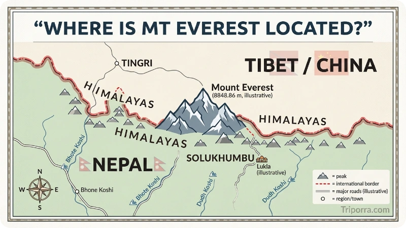
Mt Everest is located in Asia, in the central part of the Himalayan mountain range. The summit sits directly on the international boundary between Nepal to the south and China’s Tibet Autonomous Region to the north.
On the Nepal side, the mountain is part of the Khumbu region in Solukhumbu District, which belongs to Koshi Province. This side is the better-known route for trekkers visiting Everest Base Camp and climbers using the Southeast Ridge.
On the Tibetan side, Everest is in Tingri County, which is part of Xigazê in the Tibet Autonomous Region of China. This northern side gives wide, open views of the mountain from the Rongbuk area.
Mt Everest belongs to the Mahalangur Himal, a sub-range of the Himalayas. Nearby giants include Lhotse, Nuptse, Cho Oyu, and Pumori. UNESCO describes Sagarmatha National Park as an area of dramatic mountains, glaciers, and deep valleys dominated by Everest.
Quick Facts About Mt Everest
Here’s a clean, reader-friendly Quick Facts table for your article.
Mount Everest Quick Facts
| Fact | Details |
|---|---|
| Official Name | Mount Everest |
| Local Names | Sagarmatha (Nepali); Chomolungma (Tibetan) |
| Entity Type | Mountain |
| Countries | Nepal and China (Tibet Autonomous Region) |
| Nepal Side | Solukhumbu District, Koshi Province |
| China Side | Tingri County, Xigazê, Tibet Autonomous Region |
| Mountain Range | Himalayas |
| Sub-Range | Mahalangur Himal |
| Elevation | 8,848.86 meters (29,031.7 feet) |
| Coordinates | Approximately 27.9881° N, 86.9250° E |
| Nearby Major Cities | Kathmandu, Lhasa, Xigazê (Shigatse) |
| Nearby Trekking Hubs | Lukla and Namche Bazaar |
| Known For | World’s highest mountain above sea level, Everest Base Camp Trek, mountaineering expeditions |
| Time Zone | Nepal: UTC+5:45; Tibet (China): UTC+8 |
| Languages Spoken Nearby | Nepali, , Tibetan, and English (in tourism areas) |
| Currency | Nepalese Rupee (NPR) in Nepal; Chinese Yuan (CNY) in Tibet, China |
| Population | No permanent population on the summit; and Tibetan communities live in surrounding valleys |
This version is SEO-friendly, easy to scan, and factually polished for a travel or geography article. It also uses the current official elevation of 8,848.86 meters (29,031.7 feet), which reflects the joint Nepal–China measurement.
Mt Everest on the Map
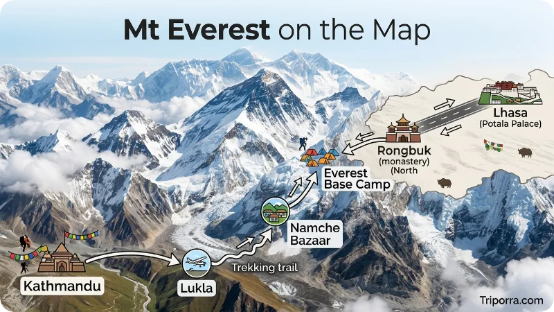
To picture Everest on a map, look at the northern edge of Nepal where the country meets Tibet. The mountain rises from a wall of high Himalayan peaks that separates South Asia from the Tibetan Plateau.
South of Everest, the land drops toward the valleys of the Dudh Koshi River and Sherpa settlement such as Namche Bazaar, Tengboche, Dingboche, and Lobuche. Trekkers on the Nepal side usually walk through this valley system before reaching Everest Base Camp.
North of Everest, the land opens toward the high, dry plateau of Tibet. The Tibetan side has broader views and a different landscape, with brown slopes, glaciated peaks, and road access closer to viewpoint areas.
Everest is not standing alone. It is surrounded by some of the most famous mountains in the world. Lhotse is very close to Everest and shares part of the climbing route. Nuptse forms a huge wall near the Nepal base camp. Ama Dablam, although lower, is one of the most beautiful peaks seen on the trek.
Which Region Does Mt Everest Belong To?
Mt Everest belongs geographically to the Himalayas and more specifically to the Mahalangur Himal. Administratively, it belongs to two different national systems because the summit lies on the Nepal-China border.
On the Nepal side, the mountain is inside the Everest region of Sagarmatha National Park, a UNESCO World Heritage Site added in 1979. Nepal Tourism Board notes that the park includes Everest, Lhotse, and Cho Oyu, along with many other peaks above 6,000 meters.
On the China side, the mountain is part of the Tibet Autonomous Region. The northern approach is linked with Tingri County and the Rongbuk area.
For travelers, this matters because entry rules, permits, transport, guides, and routes are different on each side. A Nepal trek to Everest Base Camp is very different from a Tibet-side road journey to viewing areas.
How Does Mt Everest Compare to Nearby Places?
Everest is the highest mountain above sea level, but nearby peaks are also huge. Lhotse, the fourth-highest mountain in the world, stands very close to Everest. Nuptse is lower than Everest but looks massive from the Khumbu valley. Ama Dablam is much lower, yet many trekkers remember it because of its sharp and graceful shape.
Compared with Kathmandu, Everest feels remote and wild. Kathmandu is a busy capital city with roads, hotels, temples, and an international airport. The Everest region has small mountain settlements, walking trails, suspension bridges, prayer flags, monasteries, glaciers, and thin air.
Compared with Everest Base Camp, the summit is a completely different challenge. Base Camp is a trekking destination for fit hikers who prepare well. The summit is for trained climbers with technical support, high-altitude experience, weather planning, and expedition permits.
Compared with K2 in Pakistan, Everest is higher and more visited. K2 is often described as more technically difficult and less commercialized. Everest receives more global attention because of its height, history, and famous trekking route.
How to Reach Mt Everest
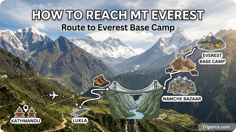
Most international visitors approach Everest from the Nepal side. The usual journey begins with a flight to Kathmandu, Nepal’s capital. From there, travelers often take a short mountain flight to Lukla, then trek through the Khumbu region.
The Nepal Tourism Board explains that the journey to Everest or Everest Base Camp begins with a flight from Kathmandu to Lukla, followed by hiking through the Everest region. The Everest Base Camp trek commonly starts and ends at Lukla and takes around two weeks for many trekkers.
A simple Nepal-side route looks like this:
Kathmandu → Lukla → Phakding → Namche Bazaar → Tengboche → Dingboche or Pheriche → Lobuche → Gorak Shep → Everest Base Camp.
There is no normal road all the way to Nepal’s Everest Base Camp. Some travelers avoid the Lukla flight by using road transport toward places such as Jiri, Salleri, or Phaplu, but this adds extra walking days.
From the Tibet side, travelers usually enter through Lhasa or other Tibetan travel routes, then continue toward Shigatse, Tingri, and the Everest viewing region. Access depends on permits and current local rules, so travelers should confirm requirements before planning.
Reaching the summit is not ordinary travel. A climbing expedition normally takes weeks because climbers must acclimatize, train, wait for safe weather, and move between high camps.
Why Is Mt Everest Famous?
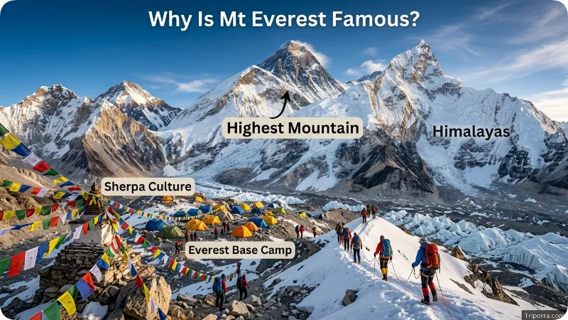
Everest is famous because it is the highest mountain on Earth above sea level. That single fact makes it a symbol of challenge, ambition, and human endurance.
Its fame also comes from the Everest Base Camp trek. Many people do not climb the summit, but they still travel to the region to see the mountain, experience Sherpa settlement, visit monasteries, cross suspension bridges, and stand near the Khumbu Glacier.
The mountain is also important culturally. The Sherpa settlement people have lived in the region for generations, and their knowledge of the high Himalayas is deeply connected to Everest travel and climbing. UNESCO highlights both the natural beauty of Sagarmatha National Park and the unique culture of the Sherpa settlement communities.
Nature adds another layer to Everest’s fame. The area includes glaciers, icefalls, deep valleys, rare wildlife, and high-altitude ecosystems. Snow leopards and red pandas are among the rare species linked with Sagarmatha National Park.
History of Mt Everest
Before the name Everest became famous worldwide, the mountain was known locally by names such as Sagarmatha in Nepal and Chomolungma or Qomolangma in Tibet. These names remain important and are widely respected.
During British survey work in the 19th century, the mountain was called Peak XV. Later, it was named Mount Everest after Sir George Everest, a former Surveyor General of India. The name became internationally common, although local names are still used in Nepal and Tibet.
Everest entered world history on May 29, 1953, when Tenzing Norgay and Edmund Hillary made the first confirmed successful ascent. Their climb became one of the most famous mountaineering achievements of the 20th century.
Modern Everest is both a natural wonder and a managed adventure destination. Climbers now use fixed ropes, high camps, weather forecasts, oxygen systems, and professional expedition support. Even with modern help, the mountain remains dangerous because of altitude sickness, cold, avalanches, crevasses, and sudden storms.
The official height has also been part of Everest’s history. In 2020, Nepal and China jointly announced the current official height of 8,848.86 meters.
Climate and Weather
Everest has an extreme high-altitude climate. The summit is cold all year, and winds can be fierce. Even during the main climbing season, conditions can change quickly.
The lower trekking areas have more seasonal variety. Spring brings clearer views, blooming rhododendrons at lower elevations, and one of the main trekking periods. Autumn is also popular because skies are often clear after the monsoon.
Winter can be very cold, especially above Namche Bazaar. Trails are quieter, but snow and ice may make travel harder. Summer overlaps with the South Asian monsoon on the Nepal side, which can bring clouds, rain at lower elevations, flight delays, and slippery trails.
For climbers, the safest weather window is usually short. Many summit attempts happen in May, before the monsoon, when winds may briefly calm near the top.
Things to See and Do Nearby
The Everest region offers much more than one mountain view. Most visitors enjoy a mix of nature, culture, and trekking.
Everest Base Camp is the best-known trekking goal. It sits on the Nepal side near the Khumbu Glacier. From there, trekkers do not usually see the full summit clearly, but the setting feels powerful because of the ice, rock, and surrounding peaks.
Kala Patthar is a famous viewpoint near Gorak Shep. Many trekkers climb it for one of the best views of Everest.
Namche Bazaar is the main Sherpa settlement town on the trail. It has lodges, shops, bakeries, gear stores, and places to rest while acclimatizing.
Tengboche Monastery is one of the most meaningful cultural stops. It offers mountain views and a peaceful connection to local Buddhist traditions.
Gokyo Lakes are another beautiful trekking destination in the wider Everest region. This route is often chosen by travelers who want turquoise lakes, fewer crowds, and views from Gokyo Ri.
Sagarmatha National Park protects mountain landscapes, wildlife, forests, glaciers, and Sherpa settlement cultural areas. It is one of Nepal’s most famous protected regions.
Best Time to Visit
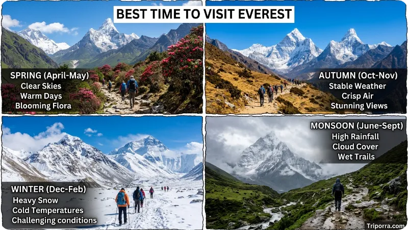
The best time to visit the Everest region is usually spring or autumn.
Spring, from about March to May, is popular for trekking and climbing. Lower valleys may have flowers, and climbing expeditions gather at Base Camp. This is also the main summit season.
Autumn, from about late September to November, is excellent for trekking. Skies are often clearer, the mountain views can be sharp, and trails are busy but lively.
Winter is possible for experienced trekkers who can handle cold weather. The trails are quieter, but high passes may be difficult.
Summer is less ideal for most trekkers on the Nepal side because of monsoon rain, clouds, and possible travel delays. Still, some travelers choose this period for fewer crowds and greener lower valleys.
Common Misconceptions
One common mistake is saying Everest is only in Nepal. The Nepal side is more famous for trekking, but the summit is on the border between Nepal and Tibet/China.
Another misunderstanding is that Everest Base Camp is the same as the summit. Base Camp is far below the top and can be reached by trekking. The summit requires a full mountaineering expedition.
Some people think Everest is the tallest mountain by every measurement. It is the highest mountain above sea level. If measured from base to peak, Mauna Kea in Hawaii is often discussed differently because much of it is below the ocean.
A further confusion is the name. “Everest” may refer to the mountain, the Everest region, Everest Base Camp, movies, schools, streets, or businesses. In geography, the main meaning is the mountain on the Nepal-China border.
Did You Mean a Different Place?
Most people searching this keyword mean Mount Everest, the world’s highest mountain. Still, “Everest” can also point to other things:
Search TermMeaningEverest Base CampTrekking destination below the mountainSagarmathaNepali name for Everest and the national park regionChomolungma/QomolangmaTibetan name for EverestEverest movieA film based on real climbing eventsEverest regionThe wider Khumbu area around the mountain
Places Related to Mt Everest
Several nearby places are closely connected to Everest travel.
Kathmandu is the main starting city for most Nepal-side trips. Travelers organize flights, permits, guides, and gear there.
Lukla is called the gateway to Everest because many trekkers begin walking from its mountain airstrip.
Namche Bazaar is the most important trail town and a major acclimatization stop.
Sagarmatha National Park protects the Nepal-side mountain environment around Everest.
Khumbu Glacier lies near Everest Base Camp and is one of the most important natural features in the area.
Rongbuk Monastery is connected with the Tibet-side view of Everest and is known for its dramatic northern perspective.
Lhotse and Nuptse are close neighboring mountains that shape the classic Everest skyline.
What Else Do People Want to Know?
Safety is one of the biggest questions. Trekking to Everest Base Camp is not a technical climb, but altitude can be serious. Travelers should walk slowly, take acclimatization days, drink enough water, and know the signs of altitude sickness.
Cost depends on the route, season, guide service, comfort level, permits, flights, and gear. A basic trek costs much less than a luxury trek, while a summit expedition can cost many times more because of permits, guides, oxygen, equipment, and logistics.
Accessibility is limited. The Nepal-side trek includes steep paths, suspension bridges, stone steps, cold nights, and high altitude. It is not a casual walk. However, many healthy travelers complete the trek with good preparation.
Local culture deserves respect. Visitors should walk clockwise around religious monuments where appropriate, ask before photographing people, dress modestly in villages and monasteries, and support local businesses responsibly.
Environmental care is also important. The Everest region is fragile. Trekkers should avoid littering, use refill systems where possible, and follow guide instructions about waste.
FAQs
Where is Mt Everest exactly?
Mt Everest is exactly on the border between Nepal and the Tibet Autonomous Region of China. The Nepal side is in Solukhumbu District, Koshi Province, and the Tibet side is in Tingri County, Xigazê.
Is Mount Everest in Nepal or China?
It is in both. The summit lies on the Nepal-China border. The southern climbing and trekking route is in Nepal, while the northern side is in Tibet, China.
What continent is Mount Everest in?
Mount Everest is in Asia. It is part of the Himalayan mountain range.
What country owns Mount Everest?
Everest is shared by Nepal and China because the summit sits on their border. Each country manages access from its own side.
What is the height of Mount Everest?
The official height is 8,848.86 meters, or about 29,032 feet, based on the joint Nepal-China announcement in 2020.
Can tourists visit Mount Everest?
Tourists can visit the Everest region and trek to Everest Base Camp on the Nepal side. Climbing the summit requires special permits, training, equipment, and expedition support.
What is the nearest airport to Mount Everest?
For most trekkers, Lukla Airport is the nearest practical airport on the Nepal side. International travelers usually fly first to Kathmandu.
How long does it take to reach Everest Base Camp?
Many Everest Base Camp treks take around two weeks from Lukla to Lukla, including acclimatization days. Some itineraries are shorter or longer.
Can you drive to Mount Everest?
On the Nepal side, you cannot drive all the way to Everest Base Camp by normal tourist road. On the Tibet side, road access gets much closer to viewing areas, but permits and rules apply.
Is Everest Base Camp dangerous?
It can be risky because of altitude, cold, ice, and remote conditions. With slow pacing, acclimatization, proper gear, and experienced guidance, many trekkers complete it safely.
Why is Mount Everest called Sagarmatha?
Sagarmatha is the Nepali name for Mount Everest. The Tibetan name is Chomolungma or Qomolangma. These local names are still widely used.
Is Mount Everest visible from Kathmandu?
Usually, Everest is not clearly visible from central Kathmandu. Some mountain flights and certain viewpoints outside the city may offer distant Himalayan views in clear weather.
Conclusion: Why Mt Everest’s Location Matters
Mt Everest is located in the Himalayas on the border between Nepal and Tibet/China. Its summit connects two countries, two major travel approaches, and one of the world’s most dramatic mountain regions.
Knowing its location helps travelers understand the difference between the Nepal trekking route, the Tibet-side viewing route, Everest Base Camp, and the summit itself. It also explains why the mountain is linked with Sherpa settlement culture, Sagarmatha National Park, high-altitude adventure, and global mountaineering history.
For most visitors, Everest is not just a point on a map. It is a journey through valleys, villages, glaciers, monasteries, and some of the highest landscapes on Earth.
About Leo Sterling
Leo Sterling is a geography and travel writer at Triporra.com who believes understanding a place starts with knowing exactly where it is. He turns geographic details on countries, regions, islands, and cities into clear, engaging content for everyday readers.
For Leo, a good location article does more than mark a spot on a map. It shows what borders a place, which region it belongs to, and how it connects to the world around it—an approach reflected in guides like where is Anguilla, where solid research meets a simple, conversational style.
Whether readers are planning a trip, studying, or just curious, Leo’s goal is the same: deliver accurate, easy-to-understand information without unnecessary complexity.
Areas of Focus: Geography | Countries & Regions | Caribbean Islands | Travel Destinations | Location Research | “Where Is?” Content










